Remember Western Street...
I lived in Western St, London E15 from 1951 until 1963/4 when we were moved out into a council flat. This was because the houses were going to be demolished as ‘slums’ and the area redeveloped. I’ve recently been trying to recollect information about the area and what it was like to live there in the 1950s and 1960s.
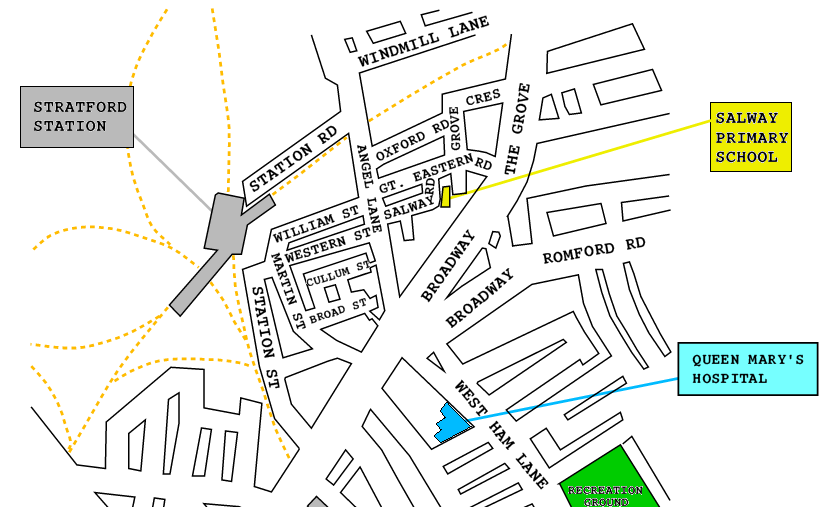
The map above shows the streets as they existed in the period around World War II. Western St and William St used to run down from Angel Lane to Stratford Station. Despite the appearance of the map, the main passenger entrance to the Station during the 1950s/60’s was where William St and Martin St met. This was accessible via steps from the corner down into a booking hall. From there, tunnels lead to the platforms. Station Rd was a goods yard entrance and – I think – a goods depot with an adjacent coal yard..
I used to attend Salway Road primary school. When going to and from school I used to walk past the Theatre Royal and I recall seeing the posters for their productions which are now a famous and important part of the history of British theatre. Alas, being young I had no idea at the time about this, and my parents never took me to any of the shows like “Oh what a lovely war” or “Fings ain’t wot they used to be”. Although I do recall going to the occasional pantomime there at Christmas! I also remember seeing bright lights at the top of Western St during the night when I think they may have been filming either “Sparrows can’t sing” or the Joe Brown picture “What a crazy world” which included a sequence in and around Cohen’s Fish and Chip shop at the top of the road on Angel Lane.
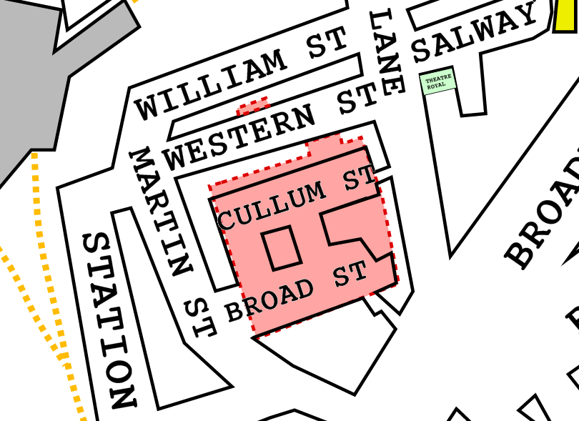
During WWII the area of Cullum St and Broad St was bombed out, as were some of the houses in Western St. The above image is a zoomed-in view with the areas that were flattened by bombing shown in red. The kids in the area used to sometimes call the flattened area that once was Cullum/Broad St “The Debry” – which I only later realised was “the debris” with the local accent applied! We used to use it as a play area. Although all the houses were gone, the square of road remained, and was useful at times as cycle racing track and sports ground.
After the war, the residents cleaned up the Debry because the council had said they’d make it into a playground and communual area. However, as with so many promises by politicians, this idea seemed to evaporate once the people had done the work and elections were over! So during the early 1960s the open area became a car park, mainly for those using Stratford Station. This meant that some of the area was covered in tar and cinders. This proved to be an excellent ‘speedway’ for some of us on bicycles. Some kids made some money washing and polishing cars.
The terraced houses were in a poor state. During the cold winter of the early 1960s I can recall waking up and finding an inch of snow on the inside of the closed window where it had blown in through the gaps in the frame. There were brown marks on the ceiling of my bedroom where leaks in the roof allowed water to drop though and soak into the plasterboards. We could normally only afford a coal fire in the living room, so the rest of the house was cold and damp. The coal was stored under the stairs. The loo was in the back yard. This only got electric light when my Dad drilled a hole in the wall between scullary and loo. He then poked an extension flex though and used a two-way adaptor from the scullary light socket. There may have been a house less than a mile away with central heating and on-tap hot water. But if so, such inventions would have been news to me! So at the time we were pleased to be given a council flat as a replacement and move out. However nowdays I regret that the community I’d grown up in was dispersed and I lost contact with my friends and neighbours. These days it would be more likely that the terraces would be renovated – alas probably then flogged off at crazy prices to people left struggling with a mortgage!
Although we were moved out before the mid 1960s the buildings weren’t actually knocked down until around 1970. The area then became the location for the new Shopping center and a multistory car park. But for many years a large part of the area remained open and unused ground.
I only have a few photos Western St or its surroundings. One is of a street party in Western St which is shown below.
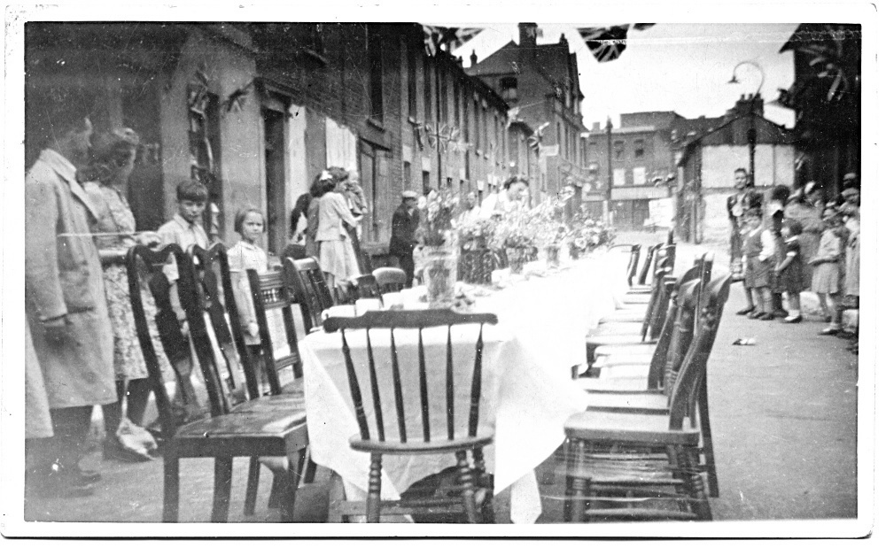
I haven’t been able to recognise any of the people in the photo, and can’t be sure of the date. However on the right, beyond the lamp-post, you can see the end of one of houses where there is a break in the terrace. This looks to me like the bombed-out gap that was an opening through to the main area of “the debry”. So I doubt the photo is pre WWII. Because of this clue I think it may have been to celebrate the Coronation of Queen Elizabeth II. Given the signs of bomb damage it seems unlikely to be a party to celebrate the King’s Jubilee before the war.
The photo was taken looking up the street towards Angel Lane. On the top left-hand corner of the street you can just see the pub which is much taller than the houses. I think the pub was called “The Lion”. This was set back from Angel Lane, and to its left – out of sight around the corner – was a sweetshop called “Nichols”. Next to that was a dining room, and on the corner of Angel Lane and Willam St was a rag-and-bone (secondhand) shop called “Shingler’s” where I used to buy old paperback books for 6d (2·5p) each! There was another sweetshop on the corner of Western St and Martin St but I can’t recall its name. Across Angel Lane at the top was a grocer’s shop, whose name I cannot recall.
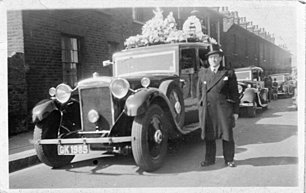
The only other images I have of the street that show more than a tiny portion are two photos taken of a funeral in May 1948. For seeing the street, the most useful of these is shown below. This shows the view from the middle of the street, but looking towards the Stratford Station/Martin St end, and the corner sweetshop at that end. The left-hand edge of the photo just shows where the terrace ends at the gap, beyond which there is an opening leading off on the left towards the bombed out “debry” area that was once Cullum/Broad Streets.
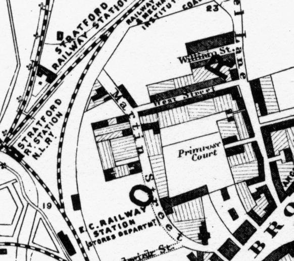
Looking at earlier maps, I found that Western St was actually older than some of the surrounding streets. The image below shows a part of a map made around 1860. Here the street is called “West St”. At that time Cullum and Broad Streets did not exist. Instead there was an area called Primrose Court, and William St was only partly built at that time. In the film of “Sparrows can’t sing” you can catch a brief glimpse of a ‘Primrose Court’ sign on the wall of an alley as the actors walk down Angel Lane.
All told Western Street seems to have existed for less than a hundred years. Now, almost all of the area is completely different. The houses and streets are all gone. Only a few places like the Theatre Royal and a – much altered – Stratford Station are still present.
If you lived in Western St or nearby and can provide any more information, please let me know and I can perhaps add more details! If you want to email me about this, please use my address given at the bottom of my main audiomisc page.
Jim Lesurf - ex. Western St.
(October 2014, edited July 2017)